 | ||||
|
|
The Cape Verde Islands
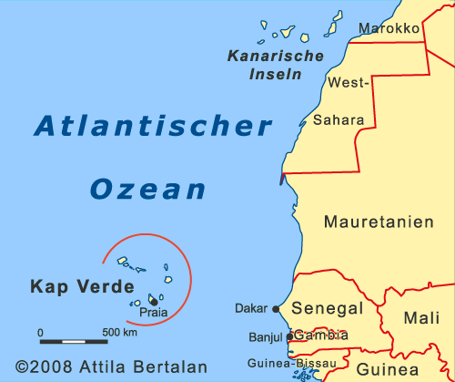
The Cape Verde Islands are an archipelago of nine inhabited islands, which lie about 560 miles west of Dakar. Formerly a Portuguese colony, since 1975 the archipelago is now the independent state "Republica de Cabo Verde" or "Cape Verde". The islands are of volcanic origin with a still active volcano on the island of Fogo. The volcanic mountain Pico de Fogo with 2829 meters, is also the highest mountain in the archipelago. It is also the second highest mountain in the Atlantic right after the Pico del Teide on the Canary island of Tenerife. The arrangement of the islands is roughly equivalent to an opening at the west horseshoe. Clockwise, first is the mountainous island of Santo Antão, followed by the dry island of São Vicente with the large port of Mindelo. It follows the now uninhabited island of Santa Luzia, then the small islands of Branco and Razo. The two small islands are a nature reserve to protect endemic bird populations. As next in the sequence follows São Nicolau and a little distance farther east, the most visited island of Sal. Sal is located south of the desert-like island Boa Vista, which is geographically an extension of the Sahara. Between Boa Vista and Maio is just below the sea surface, the reef João Valente. You can see the reef from the air as a white spot appears in the middle of the ocean. Also further south there is the flat island of Maio. Maio lies just 10 minutes by air from the west close to the main island of the archipelago known as Santiago with the capital Praia. Then follows in the west the aforementioned volcanic island of Fogo and the former hard to reach small island of Brava. Just north of Brava is a further accumulation of small uninhabited islands, Ilhéus Secos or Ilhéus Rombo.
Cape Verde can be split into two groups: The northern Ilhas de Barlavento and the southern Ilhas de Sotavento. However, Geographically a classification in three groups makes more sense: First, the more mountainous islands in the northwest, then three more flat and dry islands in the East, and in the southwest again more mountainous islands. Although one may summarize the islands into groups, but every island has its own character. Cape Verde makes it a worthwhile destination for individual travelers who are willing to explore multiple islands. Reliable wind conditions, waves and marine life make the Cape Verde islands also become a top destination for kite and wind surfers, divers, sailors and sea anglers. Long sandy beaches and mild temperatures attract more and more beach-goers on the flat islands, which are not always at their expense, as the tourist infrastructure does not yet meet international standards. Also value for money is not yet ideal and the constant wind makes long lie along the beach rather unpleasant. ©Attila Bertalan - Impressum - Datenschutz - Bildnutzungsrechte - Über mich |
|||


